FIRE, WEATHER & THE NEXT CHAPTER
The Wind Has a Vote.
Norte, Bryson and Peak are burning under the same Santa Ana pattern. Their next chapters may look very different.
Reported analysis · October 17, 2026
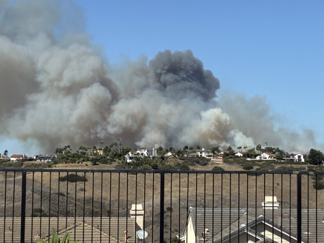
There is a temptation, when three fires appear on the same Southern California map, to read them as one story. The Santa Anas are blowing. The hills are dry. Another terrible October is writing itself.
But Saturday’s numbers tell three different stories. Bryson, in Malibu, is gaining containment. Peak, near Azusa, has held at the same reported size. Norte, the fire closest to our corner of South Orange County, has a much younger, less secure perimeter. The weather connects them. It does not give them identical futures.
The question worth asking is whether the wind will give firefighters enough room to change the ending.
Norte Fire
San Clemente / South OC
- Reported acres
- 570
- Containment
- 5%
Bryson Fire
Malibu · Los Angeles County
- Reported acres
- 147
- Containment
- 52%
Peak Fire
Azusa · Los Angeles County
- Reported acres
- 43
- Containment
- 41%
The first clue is what stopped growing
Norte’s Friday reports went from 10 acres shortly after noon to 250 by 1:07 p.m., then 570 by evening. Saturday morning brought the first small foothold: 5% containment, with the reported acreage unchanged. OCFA said crews had spent the night attacking the fire and strengthening lines. Six homes had been damaged or destroyed. That is a consequential night’s work, and a very incomplete perimeter. Norte incident updates.
Bryson offers a different trajectory: 17% containment Friday morning, 39% Friday night, 52% Saturday morning, while the reported footprint stayed at 147 acres. Its earlier 200-acre estimate was revised; the fire did not unburn the difference. Peak’s Saturday update confirmed 43 acres and 41% containment, unchanged from Thursday evening. Bryson reports · Peak reports.
Read together, these are reasons to watch the trend, not simply rank three ominous dots by size. Growing containment on a stable footprint is a different signal from a fresh fire still expanding. Containment measures secured perimeter, not the percentage extinguished; a large unsecured section can still matter enormously. Fire-science explanation.
A wind machine with a thermostat attached
A Santa Ana starts with a pressure difference: inland high pressure pushes air toward lower pressure offshore. Descending air compresses and warms. Mountain passages channel the flow. The result is a wind that can be warm, dry and far stronger in an exposed corridor than in the garden where you are checking it. National Weather Service.
Heat matters, but temperature alone is a poor narrator. A hot afternoon with easing winds is a different setup from a hot afternoon with persistent gusts. Humidity, vegetation moisture, slope and wind alignment shape the fire’s opportunities. Wind can push flames toward unburned fuel and transport burning material ahead of the main front; slope can bring fuel closer to the heat. NWCG: weather and fuel moisture · Slope and spread.
For Ladera’s forecast point, Saturday’s NWS outlook calls for 92°F, east winds up to 20 mph and gusts to 30. The hourly guidance steps down to about 10 mph around noon and 5 mph from the southeast at 2–3 p.m., with afternoon humidity roughly 23–26%. Sunday is forecast near 87°F, with south winds of 5–10 mph. These are forecast values, not a thermometer or anemometer reading from the fire line. Ladera forecast · Hourly data.
That sounds like an opening. It is also a neighborhood forecast. NWS San Diego’s regional discussion keeps stronger winds in exposed passes and slopes, with the broader Santa Ana pattern weakening later Saturday into Sunday. Ladera’s quieter afternoon cannot be pasted onto a Malibu canyon or an Azusa hillside. NWS regional discussion, October 17.
What 2007 still has to teach us
The useful comparison with past fires is the sequence of events, not the final acreage.
During the October 2007 fire siege, the National Weather Service recorded an 85-mph gust at Fremont Canyon. Some locations endured winds above 50 mph for more than 36 consecutive hours. The Witch Creek, Harris and Santiago fires burned during that sustained wind event. Duration was part of the danger: repeated hours of wind kept giving fires opportunities to move. Those historical extremes are not today’s Ladera forecast. NWS Southern California weather history.
Then there is the uncomfortable lesson from the Witch and Guejito fires at The Trails in Rancho Bernardo. NIST’s reconstruction documented vegetation ignitions from spotting before the main fireline arrived. Its study found that two-thirds of the homes destroyed in that neighborhood were ignited directly or indirectly by embers. A fire’s progress can involve new starts ahead of the edge we are watching. NIST timeline · NIST findings.
The comparison gives us two things to look for today: how long strong winds persist at each incident, and whether crews report spotting beyond established lines. A calmer forecast helps most when it becomes calmer weather where the work is happening.
Our read on the next chapter
Norte has the most to gain from a weather break—and the lowest containment of these three. If winds ease at the incident as the South OC pattern relaxes, our working expectation is a better opportunity to hold the footprint and add containment. The overnight acreage plateau supports that possibility. New spot fires, renewed gusts or a reported line breach would quickly weaken it.
Bryson’s trend favors further consolidation if local conditions cooperate. The evidence is successive containment gains without an expanding reported footprint. That supports watching for another increase in secured perimeter, rather than assuming Friday’s early growth will simply repeat. A new run outside the existing footprint would overturn that reading.
Peak looks steadier on the available reports, but its containment trend is flat. Stable acreage supports a holding pattern; an unchanged percentage does not tell us how much difficult work remains. The next useful signal is a new command update showing continued holding or additional containment.
These are conditional editorial judgments from the reports and weather, not a numerical spread-model run. Scientists have simulated the 2007 Santa Ana fires by coupling atmospheric and fire models; the lesson is to account for their interaction, not draw a straight arrow from a wind forecast. Kochanski and colleagues, Real time simulation of 2007 Santa Ana fires.
For Ladera, Norte remains the nearby incident to follow. The encouraging possibility is that its next chapter will be measured in secured perimeter rather than new acreage. The evidence to watch is wonderfully unglamorous: another unchanged footprint, fewer reports of spotting, another stretch of line that holds.
The wind gets a vote. So do the crews working through the night.
Reported October 17, 2026; sources checked at 10:30 a.m. PT. This is a dated analysis. For decisions about your address, use OC Sheriff evacuation information and follow official instructions. Our go-bag guide covers preparation.
The regional map supplied with the original briefing
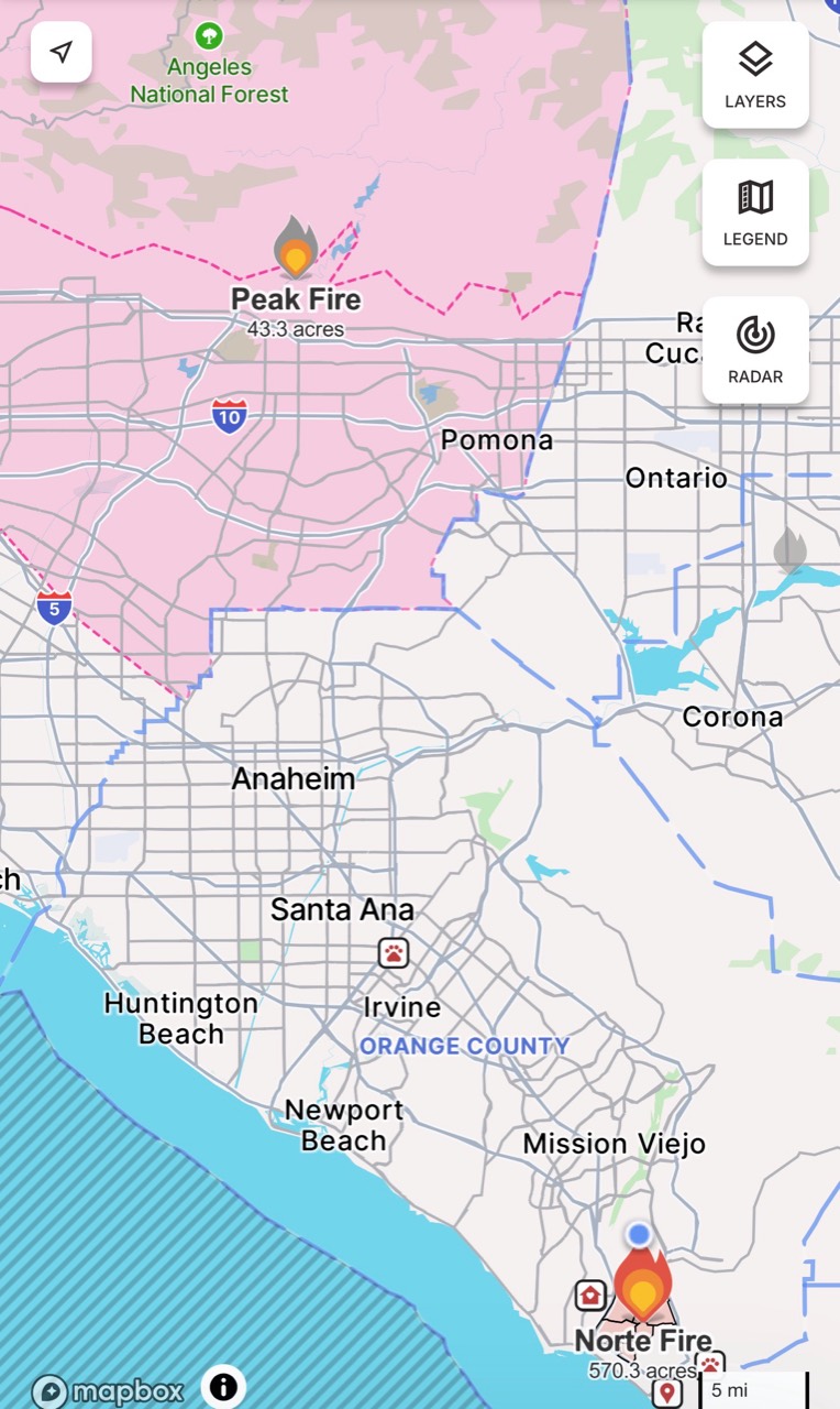
Snapshot for orientation. Capture time and layer legend are unverified; use official maps for current boundaries.


Be the first to comment.